 Agent
Agent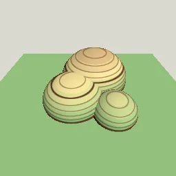
What this component contains
ATTRIBUTION.mdLICENSEREADME.mdcomponent.jsondemo.tscninspect_shader.pymaterial.trespreview.pngtest_package.pytopographic_contours.gdshaderverification/native.json
How it works
- Shader type
- spatial
- Parameters
- interval (float = 0.1), major_every (int = 5), line_pixels (float = 1), line_color (vec4 = 0.35, 0.22, 0.12, 1), height_low (float = -0.5), height_high (float = 0.6), low_tint (vec4 = 0.55, 0.75, 0.5, 1), mid_tint (vec4 = 0.9, 0.85, 0.6, 1) and 2 more
- Result
- Hills shaded in green, sand and brown bands with brown contour rings that thicken every fifth line.
- Renderers
- compatibility: compiled and rendered, forward plus: not verified, mobile: not verified
- Placement
- res://baltor/godot_shaders/topographic_contours/
Recorded checks
godot 4.7.2.stable.official.ed1daf0bf
contract_staticengine_runengine_log_cleanshader_in_scenecapture_writtenrender_not_uniformshader_changes_pixels
Limits to consider
On flat areas exactly at a contour height the line covers the whole surface. Lines on near-vertical walls bunch together. Heights are world Y, so the material must not move vertically to keep the map stable.